
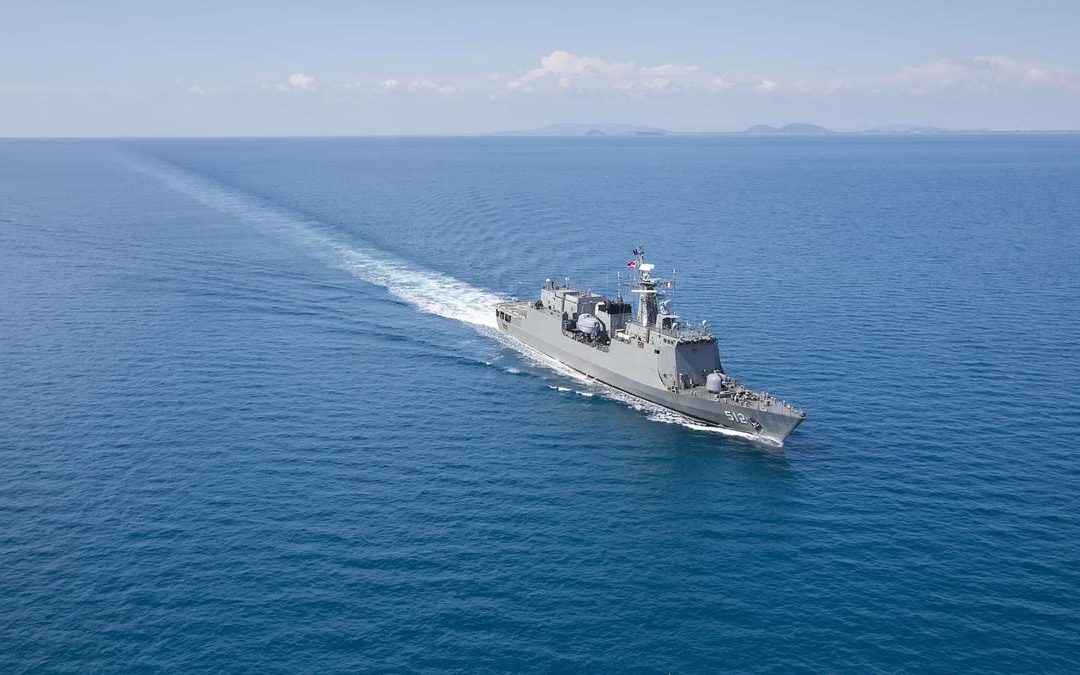
A report has been released that China is able to track US warships wherever they are in the oceans. It furthermore asserts that China is able (or may be able) to not only track US warships but identify what type of warships they are. This would give China a very significant advantage in any war with the USA. Reportedly, China can identify US warships via satellite technology that is open-sourced (free) to anyone. The satellite photos are free, but the technology that can identify US warships is apparently based on an algorithm that analyzes the wave patterns that follow in the wake of every propelled ship. The wave patterns would be a kind of “fingerprint” for each ship if analysts have access to a large volume of informational satellite photos.
If true, this begs many questions, such as: Why did China admit they had such technology? Did they do it to intimidate the USA before China invades Taiwan? Did Chinese spies find out the USA already knew China had this technology so they felt they were safe to proclaim it as a Chinese advantage? How long has China had this technology? Another question is: Does the USA have similar technology and Chinese spies stole it from the USA? This technology is described below in the first link, second link and third link. The fourth link is a “cut and paste” effort to print the text of a link that I was unable to transfer to my blog.
The technology seems easy enough for anyone with a big enough library of satellite photos. One needs to develop an analytical pattern of known warship wave actions behind a ship as it passes though the ocean (AI should be very helpful to do this). It also seems to me that it is easy enough to counter this technology. All the Navy needs to do is affix some kind of an object on the rear hull of its warships sufficient to alter the wave patterns on the waters behind the rudders and propellers as a ship passes. This should be able to be done fairly inexpensively as it requires no major modifications of the warships. All that is needed is a small structure strategically located on the rear hull to alter the wave patterns behind a ship as it passes through the water. Even a subtle shift in the wave patterns behind each ship will cancel out the value of any Chinese algorithm which identifies warship classifications by past wave patterns. Indeed, a permanent “fix” which would counter this technology could be achieved by making the small added structure flexible enough to be automatically altered in its shape to create randomized wave patterns behind each warship.
The solution is so simple that perhaps China released this information because the USA has already begun a program to create randomized wave patterns behind each US warship. Large ocean-going merchant ships could also be fitted with such counter-technology.
During the Cold War, both the USA/NATO and the USSR worked feverishly to develop technologies so each power could locate and trace the movements of each other’s submerged submarines. I recall one technology involved the detection of magnetic anomalies created when a large metallic submarine passed through the water. The earth has an electromagnetic field and large metallic objects alter that ambient magnetic field in detectable ways. That submarine-detecting technology was deployed, if I recall correctly, on a system of geostationary, military satellites orbiting the earth over each ocean. Obviously, each superpower would try to counter that technology with a defensive technology to confuse or “blind” rival satellites. I recall reading year ago that technologies had been developed by the US Navy that effectively made the oceans “transparent” so all submarines could be seen at any given time by spy satellites. I have little doubt that the American XB-37 orbital vehicle, an unmanned, “mini” space shuttle which can stay aloft for years if necessary, has been testing new US technologies of all kinds during its lengthy space missions as it is a military program. See the third link for many informational options about the XB-37 program. Some things are known about it, but I’m sure many of its capabilities and missions are classified.
The above information highlights the intense technological contest between China and the USA is as each power seeks an advantage over the other. Do not forget that Russia, larger European NATO nations, Israel, Japan and India are, no doubt, also developing technological military advantages as quickly as possible.
The Bible warns in Matthew 24:6 that “wars and rumors of wars” will characterize the latter days of our current age. Revelation 13:1-5 foretells that a globally-powerful entity called the “beast” power will rule for only 42 months before it is utterly destroyed by a heavenly army led by a returning Jesus Christ (Revelation 19:11-20:1-4). Revelation 13:4’s language clearly prophesies that the beast power, when it is revealed, will also unveil previously-unknown military technologies because the surprised nations will say “Who is able to make war with him?”
Maybe then we’ll discover which nation or nations built many of the UFOs that have been seen all over the world since the Roswell incident in 1947. Unmanned, computer-controlled UFOs would be able to do the rapid, 90 degree turns which would kill any human in such a craft due to high G forces. I suspect some UFOs seem to “disappear” because they are engaging invisibility or “cloaking” devices such as were depicted on the Star-Trek movies and TV programs. There was a flurry of press articles about a decade ago that nations were developing such cloaking technology, but then all media coverage on this topic seemed to vanish.
China’s claimed ability to detect US warships and identify their specific class based on the wave patterns behind each ship gives us a small glimpse “behind the veil” of what the nations are doing to develop secret military technologies. I think we would marvel if we knew all that was being developed.
My thanks to a friend who alerted me to this story.
- https://
interestingengineering.com/ military/china-tracks-us-navy- via-free-satellite-images - https://asiatimes.com/2024/07/
new-china-algorithm-puts-us- warships-in-clearer-view/ - https://www.google.com/search?
client=firefox-b-1-d&q=XB-37+ space+vehicle
Chinese team says it can track US warships using free low-resolution satellite images
- Team led by Hong Jun of the Dalian Naval Academy says it has tracked US Navy carrier, cruiser and destroyer by analysing images of waves
Chinese naval scientists have unveiled a method to identify and track US warships around the globe using low quality satellite images that are free and available to anyone.
The satellite photos potentially have a resolution of tens, or even hundreds, of metres, meaning that a large ship may only occupy a single pixel, or even less, making it invisible to the naked eye.
However, a team led by Hong Jun of the Dalian Naval Academy, said it had discovered a US Nimitz-class aircraft carrier, a Ticonderoga-class cruiser and an Arleigh Burke-class destroyer from these images.
Their method focuses on analysing the waves behind the ships, a simple technique that could be used by almost any country or organisation. Different ships create distinct wave patterns on the sea surface, similar to fingerprints.
However, they said accurately identifying specific US warship models required the use of sensitive parameters.
In a peer-reviewed paper published in the Chinese academic journal Computer Simulation in April, Hong and his collaborators from the Navy Submarine Academy disclosed their physical parameters.
Using these parameters and the algorithm provided in the paper, “it is possible to basically identify the target warship model under certain conditions,” the team wrote in the paper.
The US has the largest fleet in the world, but many of its warships are built with legacy technologies and concepts from the Cold War era.
While the attacks applied pressure to US military officers and soldiers, there is no direct evidence the Houthis had hit a US warship.
Accurate and timely intelligence is a necessary condition for hitting a moving warship hundreds of kilometres away.
In recent years, China has established a vast network of Earth observation satellites. According to state media reports, data revealed by Professor Li Deren, who received the country’s highest science and technology award this year, the resolution of these satellites could reach 0.1 metres (4 inches), equal to that of American Keyhole spy satellites.
China’s powerful satellites not only monitor warships but also track high-speed F-22 stealth fighter jets through clouds.
However, for countries or organisations without these capabilities, there are platforms that provide near-real-time satellite imagery for free, although their image resolution is relatively low.
For example, Nasa’s Worldview has a resolution of 250 metres (820 feet) – the area corresponding to a single pixel exceeds the deck of the US Ford-class aircraft carrier, the largest in the US navy.
However, the wake of a ship can extend up to tens of kilometres. For Hong and his colleagues, even the blurriest satellite photos could contain useful information to identify ships.
One of their challenges was how to extract useful information from environmental noise, with clouds and waves often obscuring the key features of a warship’s wake.
The Chinese scientists detailed in their paper how to eliminate interference and enable computers to quickly detect targets of interest.
However, they warned that the method might fail when the target was moving faster than 20 knots (23mph, 37km/h).
Furthermore, “under the influence of strong winds and waves, the linear and non-linear superposition relationship between sea waves and ship wakes can significantly affect the results”.
“This method still needs to be tested and refined with a large amount of actual data,” they said.
